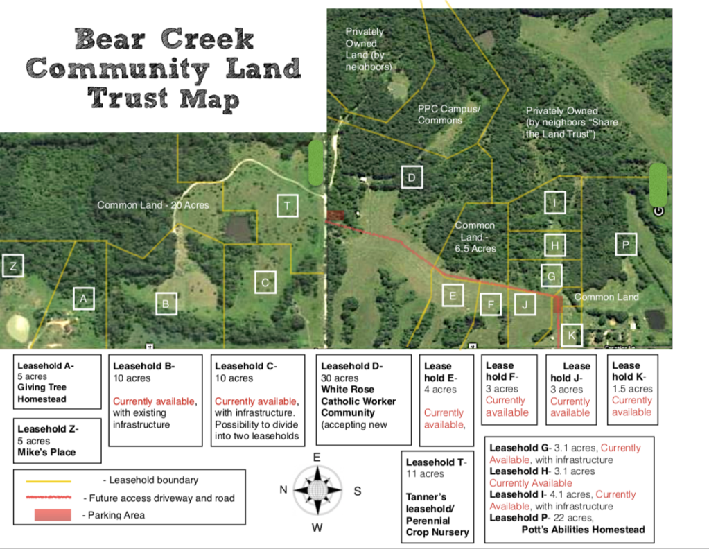
Currently, Bear Creek Community Land Trust has 11 leaseholds in addition to our Common land. They are shown on the above map and are leased/available as follows:
- Leasehold A– 10 acres, currently leased
- Leasehold B — 10 acres, with existing infrastructure, available for lease
- Leasehold C — 9 acres, with existing infrastructure, available for lease
- Leasehold D– 30 acres, currently leased
- Leasehold E — 4 acres, with minimal infrastructure, available for lease
- Leasehold F — 3 acres, raw land, available for lease
- Leasehold G — 3.1 acres, with infrastructure, available for lease
- Leasehold H — 3.1 acres, raw land, available for lease
- Leasehold I — 4.1 acres, with infrastructure, available for lease
- Leasehold J — 3 acres, raw land, available for lease
- Leasehold K — 1.5 acres, intended for a shared community building
- Leasehold P — 22 acres, currently leased
- Leasehold T — 11 acres, currently leased
For detailed pricing information on each leasehold, please contact us via email with your specific inquiries. Within Bear Creek, the value of land per acre appreciates very gradually according to a schedule. As of March 2024, the current price per acre of land is $2,198.72. Additional value and costs apply to any infrastructure and developments such as houses, outbuildings, fruit trees, and gardens.
It’s possible for an individual or group to lease more than one leasehold if additional acreage is desired. The boundaries shown for unleased land marked as leaseholds are somewhat fluid – incoming members may create proposed land boundaries for a leasehold that include the infrastructure and features desired, which are then considered by the existing membership.
Road access to Bear Creek is provided along the lower edge of the map via Frontier Lane (north-south) and along Ferrier Lane (east-west), the straight white line bisecting the map. The red line indicates an internal access road currently in the planning and development stages by BCCLT. This internal road has been graveled from Frontier Lane to a parking area near The Longhouse on leasehold G. The remaining length of the road is currently packed dirt, with plans to add gravel in the future. Parking areas are marked by red rectangles on the map.
While a bird’s-eye view map provides an overview, it may not fully convey the hilly topography, waterways, ponds, and diverse forests. The best way to truly appreciate this beautiful land is to plan a visit and experience it firsthand!